
Shirley topographic map
Click on the map to display elevation.
About this map
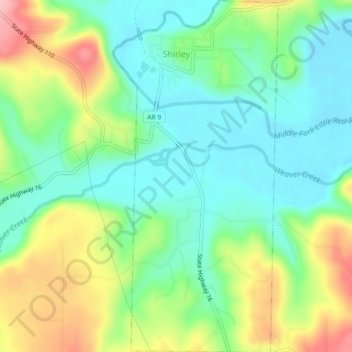
Name: Shirley topographic map, elevation, terrain.
Location: Shirley, Van Buren County, Arkansas, 72153, United States (35.62634 -92.32541 35.66295 -92.30434)
Average elevation: 673 ft
Minimum elevation: 499 ft
Maximum elevation: 997 ft
Van Buren County trails, hiking, mountain biking, running and outdoor activities
Other topographic maps
Click on a map to view its topography, its elevation and its terrain.
Fairfield Bay
United States > Arkansas > Van Buren County > Fairfield Bay > Fairfield Bay
Average elevation: 738 ft