Geolocate

Mullaca topographic map

Click on the map to display elevation.

About this map

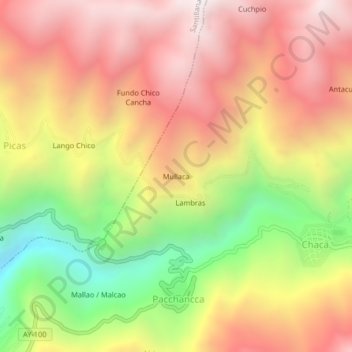
Name: Mullaca topographic map, elevation, terrain.

Location: Mullaca, Chaca, Huanta, Ayacucho, Perú (-12.79671 -74.24208 -12.75671 -74.20208)

Average elevation: 11,975 ft

Minimum elevation: 9,393 ft

Maximum elevation: 13,986 ft

Gear up for your next adventure:

📡GPS Antenna Upgrade - Enhance GPS reception in remote terrain
📱Heavy-Duty Phone Cases - Drop-proof and waterproof protection for outdoor navigation
💧Water Filtration Bottles - Safely drink from streams and lakes while exploring
🎒Hydration Pack - Hands‑free water reservoir for long hikes
🪑Ultralight Camp Chairs - Portable seating for resting after a long day of mapping

As an Amazon Associate, this site earns from qualifying purchases at no extra cost to you.