
Make a donation
Gear up for your next adventure:
As an Amazon Associate, this site earns from qualifying purchases at no extra cost to you.
Bronnen topographic map
Click on the map to display elevation.
Make a donation
Gear up for your next adventure:
As an Amazon Associate, this site earns from qualifying purchases at no extra cost to you.
Bronnen
Im Jahr 2022 erzielte Gammertingen Einnahmen aus der Gewerbesteuer in Höhe von 2,77 Millionen Euro. Mit einem Gewerbesteuerhebesatz von 350 % liegt die Stadt unter dem durchschnittlichen Gewerbesteuerhebesatz Deutschlands. Dieser beträgt 407 % (Stand: 2023).
Make a donation
Gear up for your next adventure:
As an Amazon Associate, this site earns from qualifying purchases at no extra cost to you.
About this map
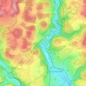
Name: Bronnen topographic map, elevation, terrain.
Average elevation: 2,428 ft
Minimum elevation: 2,149 ft
Maximum elevation: 2,684 ft
Make a donation
Gear up for your next adventure:
As an Amazon Associate, this site earns from qualifying purchases at no extra cost to you.