
Make a donation
Gear up for your next adventure:
As an Amazon Associate, this site earns from qualifying purchases at no extra cost to you.
Naninne topographic map
Click on the map to display elevation.
Make a donation
Gear up for your next adventure:
As an Amazon Associate, this site earns from qualifying purchases at no extra cost to you.
Naninne
Naninne is gelegen op een heuvelrug en overziet een dal dat langzaam in westelijke richting afloopt naar het oude Dave en de Maas. Van oudsher heeft de plaats een landelijk karakter met veel weidelandschappen rondom, die begrensd worden door bossen, en die door veel wandelpaden worden doorsneden. De hoogte aan de kerk bedraagt 195 meter.
Make a donation
Gear up for your next adventure:
As an Amazon Associate, this site earns from qualifying purchases at no extra cost to you.
About this map
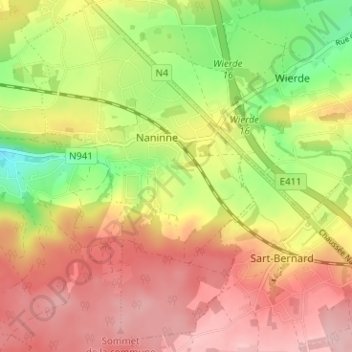
Name: Naninne topographic map, elevation, terrain.
Location: Naninne, Namen, Wallonië, België (50.39433 4.90513 50.43456 4.94567)
Average elevation: 673 ft
Minimum elevation: 341 ft
Maximum elevation: 919 ft
Make a donation
Gear up for your next adventure:
As an Amazon Associate, this site earns from qualifying purchases at no extra cost to you.
Other topographic maps
Click on a map to view its topography, its elevation and its terrain.
Make a donation
Gear up for your next adventure:
As an Amazon Associate, this site earns from qualifying purchases at no extra cost to you.