
Fire Island topographic map
Click on the map to display elevation.
About this map
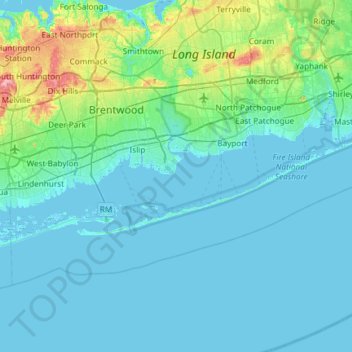
Name: Fire Island topographic map, elevation, terrain.
Average elevation: 30 ft
Minimum elevation: -10 ft
Maximum elevation: 305 ft
Suffolk County trails, hiking, mountain biking, running and outdoor activities
Other topographic maps
Click on a map to view its topography, its elevation and its terrain.
South Setauket
United States > New York > Suffolk County > Town of Brookhaven
Average elevation: 144 ft
Great South Bay
United States > New York > Suffolk County > Town of Brookhaven
Average elevation: 0 ft
Cherry Grove
United States > New York > Suffolk County > Town of Brookhaven > Fire Island Pines
Average elevation: 0 ft
Eastport South Manor Athletic Complex
United States > New York > Suffolk County > Town of Brookhaven > Eastport
Average elevation: 49 ft