Geolocate

Penryn topographic map

Click on the map to display elevation.

About this map

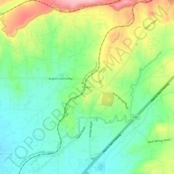
Name: Penryn topographic map, elevation, terrain.

Location: Penryn, Placer County, California, 95663, United States (38.83212 -121.18939 38.87212 -121.14939)

Average elevation: 597 ft

Minimum elevation: 390 ft

Maximum elevation: 955 ft

Placer County trails, hiking, mountain biking, running and outdoor activities

Other topographic maps

Click on a map to view its topography, its elevation and its terrain.

Lincoln

United States > California > Placer County

Average elevation: 112 ft

Avery's Pond

United States > California > Placer County

Average elevation: 620 ft

Tahoe Vista

United States > California > Placer County > Kings Beach

Average elevation: 6,644 ft

Dollar Point

United States > California > Placer County

Average elevation: 6,414 ft

Auburn Ravine

United States > California > Placer County > Auburn

Average elevation: 814 ft

Deer Lake

United States > California > Placer County

Average elevation: 6,624 ft

Lincoln

United States > California > Placer County

Average elevation: 197 ft

Gear up for your next adventure:

🎒Trekking Poles - Sturdy poles for balance and stability on rough terrain
🗺️Topographic Maps - Detailed topo maps for hiking, exploring and outdoor navigation
🦟Ultrasonic Repellers - Create a bug-free zone at your camp or rest stop
🛡️Insect Repellent - Protection against bugs during outdoor activities
🪶Camp Gear Gift Set - Perfect gift bundle for outdoor fans

As an Amazon Associate, this site earns from qualifying purchases at no extra cost to you.