Geolocate

Pike Lake topographic map

Click on the map to display elevation.

About this map

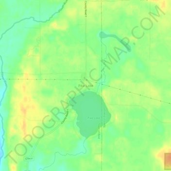
Name: Pike Lake topographic map, elevation, terrain.

Location: Pike Lake, Town of Reid, Marathon County, Wisconsin, 54440, United States (44.80164 -89.37178 44.84164 -89.33178)

Average elevation: 1,250 ft

Minimum elevation: 1,194 ft

Maximum elevation: 1,306 ft

Other topographic maps

Click on a map to view its topography, its elevation and its terrain.

Wausau

United States > Wisconsin > Marathon County

According to the United States Census Bureau, the city has a total area of 20.33 square miles (52.7 km2), of which 19.22 square miles (49.8 km2) is land and 1.11 square miles (2.9 km2) is water. The city is located at an altitude of 1,195 feet (364 m). Wausau is close to the center of the northern half of the…

Average elevation: 1,293 ft

Marathon City

United States > Wisconsin > Marathon County

Average elevation: 1,276 ft

Town of Texas

United States > Wisconsin > Marathon County

Average elevation: 1,355 ft

Town of McMillan

United States > Wisconsin > Marathon County

Average elevation: 1,266 ft

Mosinee

United States > Wisconsin > Marathon County

Average elevation: 1,171 ft

Stratford

United States > Wisconsin > Marathon County

Average elevation: 1,253 ft

Town of Wausau

United States > Wisconsin > Marathon County

Average elevation: 1,348 ft

Mosinee

United States > Wisconsin > Marathon County

Average elevation: 1,171 ft

Town of Wausau

United States > Wisconsin > Marathon County

Average elevation: 1,348 ft

Town of Weston

United States > Wisconsin > Marathon County

Average elevation: 1,253 ft

Mosinee

United States > Wisconsin > Marathon County

Average elevation: 1,171 ft

Town of Knowlton

United States > Wisconsin > Marathon County

Average elevation: 1,152 ft

Wausau

United States > Wisconsin > Marathon County

According to the United States Census Bureau, the city has a total area of 20.33 square miles (52.7 km2), of which 19.22 square miles (49.8 km2) is land and 1.11 square miles (2.9 km2) is water. The city is located at an altitude of 1,195 feet (364 m). Wausau is close to the center of the northern half of the…

Average elevation: 1,293 ft

Village of Weston

United States > Wisconsin > Marathon County

Average elevation: 1,217 ft

Schofield

United States > Wisconsin > Marathon County

Average elevation: 1,194 ft

Town of Johnson

United States > Wisconsin > Marathon County

Average elevation: 1,421 ft

Gear up for your next adventure:

🦶Hiking Gaiters - Keep debris and water out of your boots
📱Solar Portable Charger - Solar power bank for charging devices off‑grid
🪶Paracord Bracelet - Survival bracelet with built‑in tools
🧭Pro Hiking Compasses - High-accuracy liquid-filled compasses for topographic orientation
👓Polarized Sunglasses - Outdoor sunglasses for glare reduction

As an Amazon Associate, this site earns from qualifying purchases at no extra cost to you.