Geolocate

Rathmines topographic map

Click on the map to display elevation.

About this map

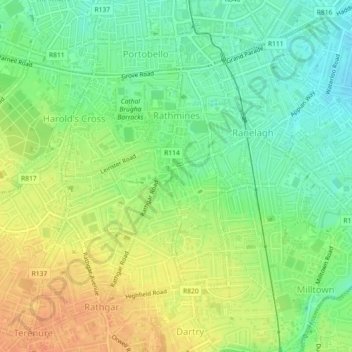
Name: Rathmines topographic map, elevation, terrain.

Location: Rathmines, Rathmines West B Ward 1986, Dublin, County Dublin, Leinster, Ireland (53.31514 -6.26598 53.32863 -6.25773)

Average elevation: 92 ft

Minimum elevation: 30 ft

Maximum elevation: 157 ft

Other topographic maps

Click on a map to view its topography, its elevation and its terrain.

Dublin Castle

Ireland > County Dublin > Dublin

The Poddle was diverted into the city through archways where the walls adjoined the castle, artificially flooding the moat of the fortress's city elevations. One of these archways and part of the wall survive buried underneath the 18th-century buildings, and are open for public viewing.

Average elevation: 52 ft

Iveagh Gardens

Ireland > County Dublin > Dublin

Average elevation: 56 ft

Griffith Park

Ireland > County Dublin > Dublin

Average elevation: 85 ft

Tolka Valley Park

Ireland > County Dublin > Dublin

Average elevation: 144 ft

Poolbeg Lighthouse

Ireland > County Dublin > Dublin

Average elevation: 0 ft

St Anne's Park

Ireland > County Dublin > Dublin

Average elevation: 43 ft

Gear up for your next adventure:

🦺Reflective Outdoor Gear - Safety gear for low‑light conditions
🔌Solar Panel Charger - Charge gear sustainably outdoors
🧭Orienteering Set - Complete compass and map reading kit
🪑Portable Camp Table - Compact table for campsite meals
🔦Powerful Headlamps - Ultra-bright hands-free lighting for night navigation

As an Amazon Associate, this site earns from qualifying purchases at no extra cost to you.