Geolocate

Collepardo topographic map

Click on the map to display elevation.

About this map

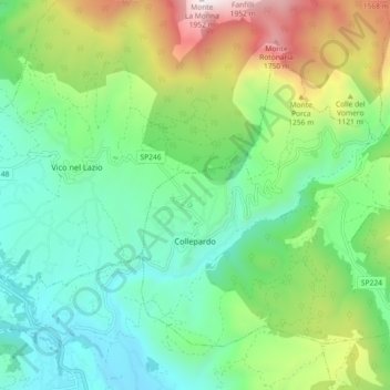
Name: Collepardo topographic map, elevation, terrain.

Location: Collepardo, Frosinone, Lazio, Italy (41.74599 13.35694 41.79865 13.44779)

Average elevation: 2,703 ft

Minimum elevation: 1,106 ft

Maximum elevation: 6,368 ft

Gear up for your next adventure:

🧥Waterproof Jacket for Hiking - Breathable and rugged rain jacket for outdoor excursions
📡Handheld GPS Device - Reliable handheld GPS for outdoor navigation
🧯Portable Fire Pit - Compact fire pit for camping spots
🎒Trekking Poles - Sturdy poles for balance and stability on rough terrain
🪶Fire Starter Kit - Reliable fire starter for survival and camping

As an Amazon Associate, this site earns from qualifying purchases at no extra cost to you.