
Make a donation
Gear up for your next adventure:
As an Amazon Associate, this site earns from qualifying purchases at no extra cost to you.
Kochkor topographic map
Click on the map to display elevation.
Make a donation
Gear up for your next adventure:
As an Amazon Associate, this site earns from qualifying purchases at no extra cost to you.
About this map
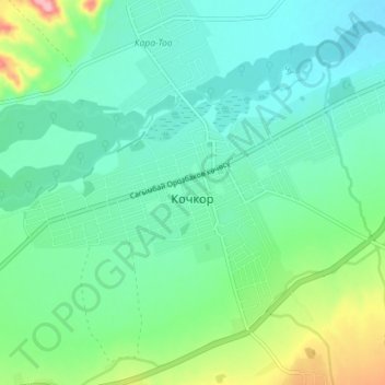
Name: Kochkor topographic map, elevation, terrain.
Location: Kochkor, Kochkor District, Naryn Region, 722800, Kyrgyzstan (42.19365 75.72035 42.23136 75.79149)
Average elevation: 5,978 ft
Minimum elevation: 5,860 ft
Maximum elevation: 6,345 ft
Make a donation
Gear up for your next adventure:
As an Amazon Associate, this site earns from qualifying purchases at no extra cost to you.
Other topographic maps
Click on a map to view its topography, its elevation and its terrain.
Son-Kul
Kyrgyzstan > Naryn Region > Kochkor District
Song-Köl (Kyrgyz: Соң-Көл, IPA: [sóɴkœl], also Соңкөл Songköl, literally "following lake", Russian: Сон-Куль, romanized: Son-Kul', also Сонкёль Sonkyol') is an alpine lake in northern Naryn Region, Kyrgyzstan. It lies at an altitude of 3016 m, and has an area of about 270 km2 and…
Average elevation: 10,154 ft