Geolocate

Wetmore topographic map

Click on the map to display elevation.

About this map

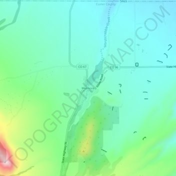
Name: Wetmore topographic map, elevation, terrain.

Location: Wetmore, Custer County, Colorado, 81253, United States (38.21848 -105.10502 38.25848 -105.06502)

Average elevation: 6,168 ft

Minimum elevation: 5,886 ft

Maximum elevation: 7,083 ft

Custer County trails, hiking, mountain biking, running and outdoor activities

Other topographic maps

Click on a map to view its topography, its elevation and its terrain.

Silver Cliff

United States > Colorado > Custer County

Average elevation: 8,225 ft

Westcliffe

United States > Colorado > Custer County

Average elevation: 7,887 ft

Westcliffe

United States > Colorado > Custer County

Average elevation: 7,887 ft

Gear up for your next adventure:

🧢Sun Protection Hats - Wide-brimmed and UPF-rated hats for high-altitude sun safety
🌲Outdoor Survival Books - Best books on survival skills
👟Trail Running Shoes - Lightweight shoes for trail runners
🪶LED Camping Lantern - Bright lantern for camp lighting
🗺️NatGeo Topo Maps - High-quality waterproof printed topographic maps of US Parks

As an Amazon Associate, this site earns from qualifying purchases at no extra cost to you.