Geolocate

Nathnagar topographic map

Click on the map to display elevation.

About this map

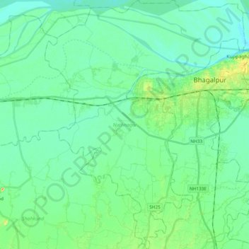
Name: Nathnagar topographic map, elevation, terrain.

Location: Nathnagar, Bhagalpur, Bihar, India (25.13219 86.85658 25.30450 87.00979)

Average elevation: 121 ft

Minimum elevation: 82 ft

Maximum elevation: 256 ft

Gear up for your next adventure:

📱Heavy-Duty Phone Cases - Drop-proof and waterproof protection for outdoor navigation
🌐World Map Poster - Decorative world maps with topographic info
🥘Titanium Cookware - Durable, featherlight pots and pans for backpacking
🔌Solar Panel Charger - Charge gear sustainably outdoors
🔪Outdoor Multitools - Essential survival tools for gear repair and field use

As an Amazon Associate, this site earns from qualifying purchases at no extra cost to you.