
Thank you for supporting this site ❤️
Make a donation
Make a donation
Gear up for your next adventure:
As an Amazon Associate, this site earns from qualifying purchases at no extra cost to you.
Minamiuonuma topographic map
Click on the map to display elevation.
Thank you for supporting this site ❤️
Make a donation
Make a donation
Gear up for your next adventure:
As an Amazon Associate, this site earns from qualifying purchases at no extra cost to you.
About this map
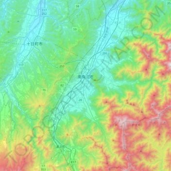
Name: Minamiuonuma topographic map, elevation, terrain.
Location: Minamiuonuma, Niigata Prefecture, Japan (36.88721 138.76461 37.20874 139.09784)
Average elevation: 2,024 ft
Minimum elevation: 295 ft
Maximum elevation: 6,755 ft
Thank you for supporting this site ❤️
Make a donation
Make a donation
Gear up for your next adventure:
As an Amazon Associate, this site earns from qualifying purchases at no extra cost to you.