Geolocate

Milan topographic map

Click on the map to display elevation.

About this map

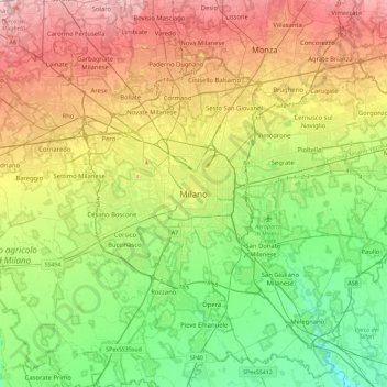
Name: Milan topographic map, elevation, terrain.

Location: Milan, Lombardy, 20122, Italy (45.30422 9.02982 45.62422 9.34982)

Average elevation: 427 ft

Minimum elevation: 223 ft

Maximum elevation: 735 ft

Other topographic maps

Click on a map to view its topography, its elevation and its terrain.

Quartiere Gallaratese

Italy > Lombardy > Milan > Milan

Average elevation: 449 ft

Gear up for your next adventure:

🧭GPS Watch Accessories - Bands and chargers for GPS watches
🧺Microfiber Travel Towels - Compact and fast-drying towels for trail use
🧤Hiking Gloves - Protective gloves for rugged trails
🧣Hiking Neck Gaiter - Multi‑use neck protection for outdoor weather
💧Water Purification System - Clean water on the trail with reliable purifiers

As an Amazon Associate, this site earns from qualifying purchases at no extra cost to you.