Geolocate

Alba topographic map

Click on the map to display elevation.

About this map

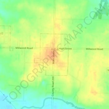
Name: Alba topographic map, elevation, terrain.

Location: Alba, Jasper County, Missouri, 64830, United States (37.23185 -94.42376 37.24225 -94.41319)

Average elevation: 955 ft

Minimum elevation: 889 ft

Maximum elevation: 1,007 ft

Jasper County trails, hiking, mountain biking, running and outdoor activities

Other topographic maps

Click on a map to view its topography, its elevation and its terrain.

Joplin

United States > Missouri > Jasper County > Joplin

Average elevation: 984 ft

Belle Center

United States > Missouri > Jasper County

Average elevation: 961 ft

Atlas

United States > Missouri > Jasper County

Average elevation: 1,037 ft

Oakland Park

United States > Missouri > Jasper County > Webb City

Average elevation: 1,020 ft

Center Creek

United States > Missouri > Jasper County > Oronogo

Average elevation: 981 ft

Gear up for your next adventure:

💧Water Purification System - Clean water on the trail with reliable purifiers
🎒Waterproof Dry Bags - Keep your electronics and maps dry inside your pack
💧Water Filtration Bottles - Safely drink from streams and lakes while exploring
👟Men's Trail Runners - Lightweight footwear for fast-paced exploration and light hiking
🪓Survival Multi‑Tool - Versatile tool for camp and trail tasks

As an Amazon Associate, this site earns from qualifying purchases at no extra cost to you.