Geolocate

Preston topographic map

Click on the map to display elevation.

About this map

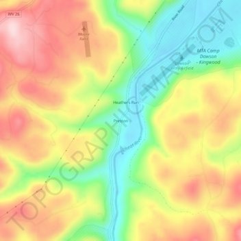
Name: Preston topographic map, elevation, terrain.

Location: Preston, Preston County, West Virginia, 26537, United States (39.41509 -79.70561 39.45509 -79.66561)

Average elevation: 1,647 ft

Minimum elevation: 1,224 ft

Maximum elevation: 2,070 ft

Preston County trails, hiking, mountain biking, running and outdoor activities

Other topographic maps

Click on a map to view its topography, its elevation and its terrain.

Terra Alta

United States > West Virginia > Preston County

Average elevation: 2,543 ft

Newburg

United States > West Virginia > Preston County

Average elevation: 1,480 ft

Rowlesburg

United States > West Virginia > Preston County

Average elevation: 1,850 ft

Big Bear Lake

United States > West Virginia > Preston County

Average elevation: 2,585 ft

Gear up for your next adventure:

📦Gear Storage Bags - Organize and protect outdoor equipment
Backpacking Tents - Weight-optimized shelters for multi-day topographic surveys
🚑Emergency Bivvies - Heat-reflective sleeping bags for survival situations
🗺️Topographic Maps - Detailed topo maps for hiking, exploring and outdoor navigation
🧦Merino Wool Socks - Moisture-wicking, blister-preventing socks for long treks

As an Amazon Associate, this site earns from qualifying purchases at no extra cost to you.