Geolocate

Rowlesburg topographic map

Click on the map to display elevation.

About this map

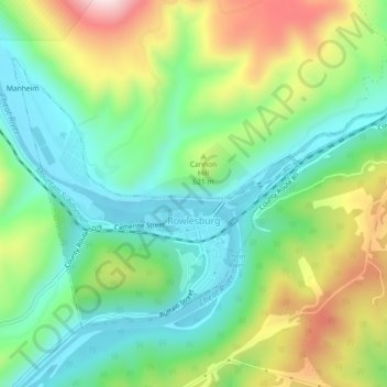
Name: Rowlesburg topographic map, elevation, terrain.

Location: Rowlesburg, Preston County, West Virginia, United States (39.33865 -79.69222 39.36304 -79.64705)

Average elevation: 1,850 ft

Minimum elevation: 1,345 ft

Maximum elevation: 2,795 ft

Preston County trails, hiking, mountain biking, running and outdoor activities

Other topographic maps

Click on a map to view its topography, its elevation and its terrain.

Heathers Run

United States > West Virginia > Preston County

Average elevation: 1,631 ft

Saint Joe

United States > West Virginia > Preston County

Average elevation: 1,581 ft

Bretz

United States > West Virginia > Preston County

Average elevation: 1,768 ft

Aurora

United States > West Virginia > Preston County

Average elevation: 2,664 ft

Horse Shoe Run

United States > West Virginia > Preston County

Average elevation: 2,582 ft

Hazelton

United States > West Virginia > Preston County

Average elevation: 2,037 ft

Big Bear Lake

United States > West Virginia > Preston County

Average elevation: 2,585 ft

Eglon

United States > West Virginia > Preston County

Average elevation: 2,677 ft

Mount Nebo

United States > West Virginia > Preston County

Average elevation: 1,811 ft

Alpine Lake

United States > West Virginia > Preston County

Average elevation: 2,723 ft

Preston

United States > West Virginia > Preston County

Average elevation: 1,647 ft

Gear up for your next adventure:

🪶Paracord Bracelet - Survival bracelet with built‑in tools
🥘Titanium Cookware - Durable, featherlight pots and pans for backpacking
🪶Camping Sleeping Pad - Comfortable sleeping pad for backpacking
🌡️Handheld Weather Meters - Measure wind, temp, and pressure for safe mountain travel
👟Men's Trail Runners - Lightweight footwear for fast-paced exploration and light hiking

As an Amazon Associate, this site earns from qualifying purchases at no extra cost to you.