Geolocate

Castanhal topographic map

Click on the map to display elevation.

Castanhal

Localizado a uma latitude 01°17'49" sul e longitude 47°55'19" oeste, estando a uma altitude de 41 metros acima do nível do mar. O município possui 1 029,300 km² de extensão territorial.

About this map

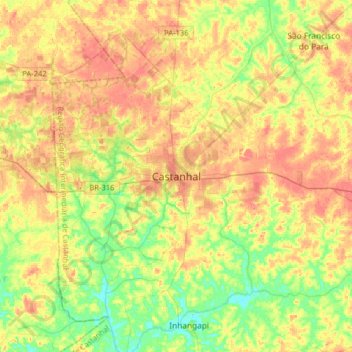
Name: Castanhal topographic map, elevation, terrain.

Location: Castanhal, Região Geográfica Imediata de Castanhal, Região Geográfica Intermediária de Castanhal, Pará, Região Norte, 68745-690, Brasil (-1.45270 -48.08239 -1.13270 -47.76239)

Average elevation: 102 ft

Minimum elevation: 3 ft

Maximum elevation: 197 ft

Gear up for your next adventure:

🛰️Handheld GPS Units - Professional satellite navigators for precise backcountry mapping
🛠️Outdoor Gear Repair Kit - Essential tools to fix gear on the trail
🕶️Glacier Sunglasses - Side shields to protect eyes from high-altitude snow glare
🗺️NatGeo Topo Maps - High-quality waterproof printed topographic maps of US Parks
🌎3D Topographic Globes - Raised relief globes for a tactile understanding of geography

As an Amazon Associate, this site earns from qualifying purchases at no extra cost to you.