
Make a donation
Gear up for your next adventure:
As an Amazon Associate, this site earns from qualifying purchases at no extra cost to you.
Orisant topographic map
Click on the map to display elevation.
Make a donation
Gear up for your next adventure:
As an Amazon Associate, this site earns from qualifying purchases at no extra cost to you.
Orisant
De zandplaat Orisant was niet de eerste keer dat op deze plaats land was. In de Romeinse oudheid lag er de van oorsprong Keltische nederzetting Ganuenta. Zij raakte bekend nadat in 1970 door een visser altaarstenen van een tempel voor de godin Nehalennia werden opgevist in de Schaar van Colijnsplaat, ter hoogte van de zuidoostpunt van het voormalige Orisant. Na het jaar 300 moet de nederzetting in het water zijn verdwenen. In 2004 werd in Colijnsplaat een replica van de tempel gebouwd.
Make a donation
Gear up for your next adventure:
As an Amazon Associate, this site earns from qualifying purchases at no extra cost to you.
About this map
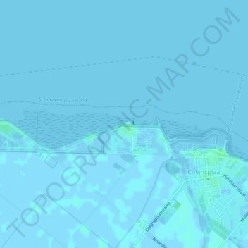
Name: Orisant topographic map, elevation, terrain.
Average elevation: 0 ft
Minimum elevation: -10 ft
Maximum elevation: 13 ft
Make a donation
Gear up for your next adventure:
As an Amazon Associate, this site earns from qualifying purchases at no extra cost to you.
Other topographic maps
Click on a map to view its topography, its elevation and its terrain.