
Thank you for supporting this site ❤️
Make a donation
Make a donation
Gear up for your next adventure:
As an Amazon Associate, this site earns from qualifying purchases at no extra cost to you.
Donghe District topographic map
Click on the map to display elevation.
Thank you for supporting this site ❤️
Make a donation
Make a donation
Gear up for your next adventure:
As an Amazon Associate, this site earns from qualifying purchases at no extra cost to you.
About this map
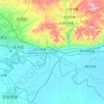
Name: Donghe District topographic map, elevation, terrain.
Location: Donghe District, Baotou City, Inner Mongolia, 014000, China (40.46107 109.94734 40.65216 110.43720)
Average elevation: 3,757 ft
Minimum elevation: 3,268 ft
Maximum elevation: 6,079 ft
Thank you for supporting this site ❤️
Make a donation
Make a donation
Gear up for your next adventure:
As an Amazon Associate, this site earns from qualifying purchases at no extra cost to you.