
Thank you for supporting this site ❤️
Make a donation
Make a donation
Gear up for your next adventure:
As an Amazon Associate, this site earns from qualifying purchases at no extra cost to you.
Chehairia topographic map
Click on the map to display elevation.
Thank you for supporting this site ❤️
Make a donation
Make a donation
Gear up for your next adventure:
As an Amazon Associate, this site earns from qualifying purchases at no extra cost to you.
About this map
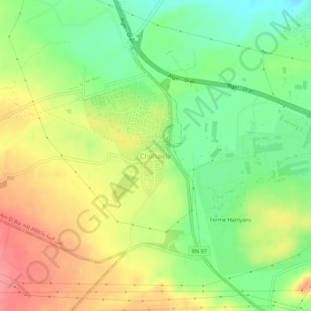
Name: Chehairia topographic map, elevation, terrain.
Location: Chehairia, Aïn El Bia, Daïra Bethioua, Oran, Algérie (35.75053 -0.30148 35.79053 -0.26148)
Average elevation: 269 ft
Minimum elevation: 144 ft
Maximum elevation: 407 ft
Thank you for supporting this site ❤️
Make a donation
Make a donation
Gear up for your next adventure:
As an Amazon Associate, this site earns from qualifying purchases at no extra cost to you.