
Make a donation
Gear up for your next adventure:
As an Amazon Associate, this site earns from qualifying purchases at no extra cost to you.
Bedretto topographic map
Click on the map to display elevation.
Make a donation
Gear up for your next adventure:
As an Amazon Associate, this site earns from qualifying purchases at no extra cost to you.
Bedretto
La commune de Bedretto dispose, dans le hameau de Cioss Prato, d'un petit domaine skiable composé d'un téléski et d'un baby-lift. Le téléski, d'une longueur de 250 m, est implanté entre 1 550 m et 1 610 m d'altitude.
Make a donation
Gear up for your next adventure:
As an Amazon Associate, this site earns from qualifying purchases at no extra cost to you.
About this map
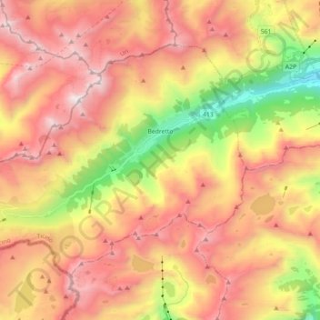
Name: Bedretto topographic map, elevation, terrain.
Average elevation: 7,372 ft
Minimum elevation: 3,750 ft
Maximum elevation: 10,305 ft
Make a donation
Gear up for your next adventure:
As an Amazon Associate, this site earns from qualifying purchases at no extra cost to you.
Other topographic maps
Click on a map to view its topography, its elevation and its terrain.
Make a donation
Gear up for your next adventure:
As an Amazon Associate, this site earns from qualifying purchases at no extra cost to you.
Corno Gries / Grieshorn
Suisse > Tessin > District de Léventine > Bedretto
Average elevation: 8,389 ft
Make a donation
Gear up for your next adventure:
As an Amazon Associate, this site earns from qualifying purchases at no extra cost to you.