Geolocate

Pugo topographic map

Click on the map to display elevation.

About this map

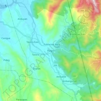
Name: Pugo topographic map, elevation, terrain.

Location: Pugo, La Union, Ilocos Region, 2508, Philippines (16.28030 120.42735 16.36030 120.50735)

Average elevation: 630 ft

Minimum elevation: 72 ft

Maximum elevation: 2,372 ft

Gear up for your next adventure:

☀️Outdoor Sunscreen - High protection sunscreen for outdoor activities
Camping Coffee Makers - Enjoy premium coffee at the summit or campsite
📚USA Hiking Guide Books - Top trail guides and map books
🧭Hiking Compass - Precision compass for reliable navigation in the wilderness
🪶Survival Guide Book - Expert advice for emergency preparedness

As an Amazon Associate, this site earns from qualifying purchases at no extra cost to you.