
Thank you for supporting this site ❤️
Make a donation
Make a donation
Gear up for your next adventure:
As an Amazon Associate, this site earns from qualifying purchases at no extra cost to you.
Jaltenango topographic map
Click on the map to display elevation.
Thank you for supporting this site ❤️
Make a donation
Make a donation
Gear up for your next adventure:
As an Amazon Associate, this site earns from qualifying purchases at no extra cost to you.
About this map
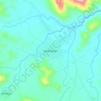
Name: Jaltenango topographic map, elevation, terrain.
Location: Jaltenango, Ángel Albino Corzo, Chiapas, Mexico (15.83183 -92.76267 15.91183 -92.68267)
Average elevation: 2,182 ft
Minimum elevation: 1,873 ft
Maximum elevation: 4,157 ft
Thank you for supporting this site ❤️
Make a donation
Make a donation
Gear up for your next adventure:
As an Amazon Associate, this site earns from qualifying purchases at no extra cost to you.