Geolocate

Bagon topographic map

Click on the map to display elevation.

About this map

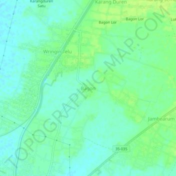
Name: Bagon topographic map, elevation, terrain.

Location: Bagon, Jember, East Java, Java, 68161, Indonesia (-8.31177 113.46891 -8.27177 113.50891)

Average elevation: 56 ft

Minimum elevation: 33 ft

Maximum elevation: 79 ft

Other topographic maps

Click on a map to view its topography, its elevation and its terrain.

Watu Ulo

Indonesia > East Java > Jember > Watuulo

Average elevation: 30 ft

Gear up for your next adventure:

🎒Day Hiking Backpack - Lightweight backpack perfect for day trips and outdoor adventures
🔋Solar Power Banks - Keep your GPS and phone charged in remote wilderness areas
🔊Portable Camp Speaker - Music and alerts at camp
💧Water Filtration Bottles - Safely drink from streams and lakes while exploring
📱Solar Portable Charger - Solar power bank for charging devices off‑grid

As an Amazon Associate, this site earns from qualifying purchases at no extra cost to you.