
Make a donation
Gear up for your next adventure:
As an Amazon Associate, this site earns from qualifying purchases at no extra cost to you.
Monte Schiara topographic map
Click on the map to display elevation.
Make a donation
Gear up for your next adventure:
As an Amazon Associate, this site earns from qualifying purchases at no extra cost to you.
Monte Schiara
The Schiara (Italian: Monte Schiara) is a mountain in the southern Dolomites of Veneto in northern Italy. It is located just north of the town of Belluno, approximately 50 miles north of Venice. Monte Schiara has an elevation of 2,565 metres.
Make a donation
Gear up for your next adventure:
As an Amazon Associate, this site earns from qualifying purchases at no extra cost to you.
About this map
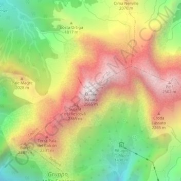
Name: Monte Schiara topographic map, elevation, terrain.
Location: Monte Schiara, Sedico, Belluno, Veneto, 32036, Italy (46.22995 12.18217 46.23005 12.18227)
Average elevation: 6,076 ft
Minimum elevation: 3,770 ft
Maximum elevation: 8,419 ft
Make a donation
Gear up for your next adventure:
As an Amazon Associate, this site earns from qualifying purchases at no extra cost to you.