
Thank you for supporting this site ❤️
Make a donation
Make a donation
Gear up for your next adventure:
As an Amazon Associate, this site earns from qualifying purchases at no extra cost to you.
Yacuanquer topographic map
Click on the map to display elevation.
Thank you for supporting this site ❤️
Make a donation
Make a donation
Gear up for your next adventure:
As an Amazon Associate, this site earns from qualifying purchases at no extra cost to you.
About this map
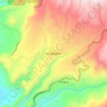
Name: Yacuanquer topographic map, elevation, terrain.
Location: Yacuanquer, Centro, Nariño, RAP Pacífico, Colombia (1.07588 -77.44176 1.15588 -77.36176)
Average elevation: 8,606 ft
Minimum elevation: 6,325 ft
Maximum elevation: 10,932 ft
Thank you for supporting this site ❤️
Make a donation
Make a donation
Gear up for your next adventure:
As an Amazon Associate, this site earns from qualifying purchases at no extra cost to you.
Other topographic maps
Click on a map to view its topography, its elevation and its terrain.