
Thank you for supporting this site ❤️
Make a donation
Make a donation
Gear up for your next adventure:
As an Amazon Associate, this site earns from qualifying purchases at no extra cost to you.
Soumagne topographic map
Click on the map to display elevation.
Thank you for supporting this site ❤️
Make a donation
Make a donation
Gear up for your next adventure:
As an Amazon Associate, this site earns from qualifying purchases at no extra cost to you.
About this map
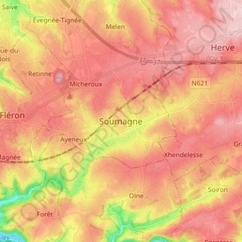
Name: Soumagne topographic map, elevation, terrain.
Location: Soumagne, Liège, Wallonie, 4630, Belgique (50.57477 5.69994 50.65477 5.77994)
Average elevation: 781 ft
Minimum elevation: 292 ft
Maximum elevation: 1,056 ft
Thank you for supporting this site ❤️
Make a donation
Make a donation
Gear up for your next adventure:
As an Amazon Associate, this site earns from qualifying purchases at no extra cost to you.
Other topographic maps
Click on a map to view its topography, its elevation and its terrain.
Domaine provincial de Wégimont
Belgique > Liège > Liège > Soumagne > Ayeneux > Basse-Rafhay
Average elevation: 741 ft