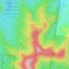
Samsonvale topographic map
Click on the map to display elevation.
About this map

Name: Samsonvale topographic map, elevation, terrain.
Location: Samsonvale, Brisbane, Queensland, Australia (-27.30749 152.80870 -27.21678 152.90738)
Average elevation: 318 ft
Minimum elevation: 85 ft
Maximum elevation: 2,152 ft
Other topographic maps
Click on a map to view its topography, its elevation and its terrain.




Caboolture Region Environmental Education Centre
Australia > Queensland > Brisbane
Average elevation: 79 ft