Geolocate

Flagstone topographic map

Click on the map to display elevation.

About this map

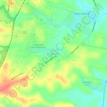
Name: Flagstone topographic map, elevation, terrain.

Location: Flagstone, Logan City, Queensland, 4280, Australia (-27.83602 152.94529 -27.79602 152.98529)

Average elevation: 144 ft

Minimum elevation: 59 ft

Maximum elevation: 259 ft

Gear up for your next adventure:

🏫Relief Map Kits - Hands-on tools for teaching landforms and elevation
🪶Thermal Camp Blanket - Extra warmth for cold nights
🛏️Cold Weather Sleeping Bag - Warm sleeping bag for cold conditions
🛡️Bear Spray Outdoor - Protection in bear country hikes
🪶LED Camping Lantern - Bright lantern for camp lighting

As an Amazon Associate, this site earns from qualifying purchases at no extra cost to you.