
Make a donation
Gear up for your next adventure:
As an Amazon Associate, this site earns from qualifying purchases at no extra cost to you.
Chäserrugg topographic map
Click on the map to display elevation.
Make a donation
Gear up for your next adventure:
As an Amazon Associate, this site earns from qualifying purchases at no extra cost to you.
Chäserrugg
Le Chäserrugg est une montagne située sur le territoire de la commune de Alt Sankt Johann dans le canton de Saint-Gall, en Suisse. Son sommet s’élève à une altitude de 2 260 mètres. Il fait partie du massif des sept Churfirsten.
Make a donation
Gear up for your next adventure:
As an Amazon Associate, this site earns from qualifying purchases at no extra cost to you.
About this map
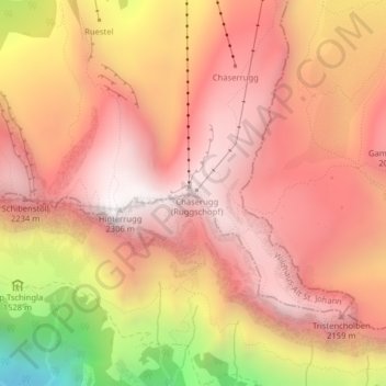
Name: Chäserrugg topographic map, elevation, terrain.
Average elevation: 6,047 ft
Minimum elevation: 2,877 ft
Maximum elevation: 7,566 ft
Make a donation
Gear up for your next adventure:
As an Amazon Associate, this site earns from qualifying purchases at no extra cost to you.