Geolocate

Kleinwallstadt topographic map

Click on the map to display elevation.

About this map

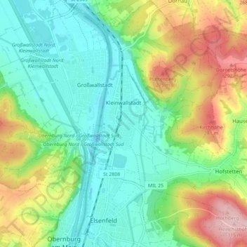
Name: Kleinwallstadt topographic map, elevation, terrain.

Location: Kleinwallstadt, Verwaltungsgemeinschaft Kleinwallstadt, Landkreis Miltenberg, Bavaria, 63839, Germany (49.84135 9.15832 49.89692 9.23206)

Average elevation: 587 ft

Minimum elevation: 358 ft

Maximum elevation: 1,047 ft

Other topographic maps

Click on a map to view its topography, its elevation and its terrain.

Hobbach

Germany > Bavaria > Landkreis Miltenberg

Average elevation: 981 ft

Gear up for your next adventure:

🪶Compact Camp Shovel - Folding shovel for campsite tasks
☀️Outdoor Sunscreen - High protection sunscreen for outdoor activities
🧭Compass with Lanyard - Easy‑carry compass for navigation
🛠️Outdoor Gear Repair Kit - Essential tools to fix gear on the trail
🌐World Map Poster - Decorative world maps with topographic info

As an Amazon Associate, this site earns from qualifying purchases at no extra cost to you.