Geolocate

Manatí topographic map

Click on the map to display elevation.

About this map

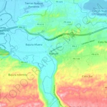
Name: Manatí topographic map, elevation, terrain.

Location: Manatí, Puerto Rico, 00701, United States (18.38714 -66.53295 18.46714 -66.45295)

Average elevation: 223 ft

Minimum elevation: -7 ft

Maximum elevation: 712 ft

Manatí trails, hiking, mountain biking, running and outdoor activities

Gear up for your next adventure:

🧯Portable Fire Pit - Compact fire pit for camping spots
🧭Orienteering Set - Complete compass and map reading kit
Backpacking Tent - Lightweight and durable tent for multi‑day hikes
📷Action Camera - Capture your outdoor adventures in HD
🚑Emergency Bivvies - Heat-reflective sleeping bags for survival situations

As an Amazon Associate, this site earns from qualifying purchases at no extra cost to you.