
Make a donation
Gear up for your next adventure:
As an Amazon Associate, this site earns from qualifying purchases at no extra cost to you.
Quadra 17 topographic map
Click on the map to display elevation.
Make a donation
Gear up for your next adventure:
As an Amazon Associate, this site earns from qualifying purchases at no extra cost to you.
About this map
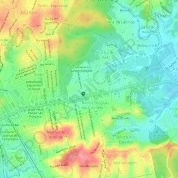
Name: Quadra 17 topographic map, elevation, terrain.
Average elevation: 161 ft
Minimum elevation: 13 ft
Maximum elevation: 364 ft
Make a donation
Gear up for your next adventure:
As an Amazon Associate, this site earns from qualifying purchases at no extra cost to you.
Other topographic maps
Click on a map to view its topography, its elevation and its terrain.
Bairro dos Estados
Brasil > Pernambuco > Região Metropolitana do Recife > Camaragibe
Average elevation: 148 ft
Camaragibe
Brasil > Pernambuco > Região Metropolitana do Recife > Camaragibe
Localiza-se a uma latitude 08º01'18" sul e a uma longitude 34º58'52" oeste, estando a uma altitude de 55 metros.
Average elevation: 190 ft
Alberto Maia
Brasil > Pernambuco > Região Metropolitana do Recife > Camaragibe
Average elevation: 161 ft
Make a donation
Gear up for your next adventure:
As an Amazon Associate, this site earns from qualifying purchases at no extra cost to you.
Bairro Novo do Carmelo
Brasil > Pernambuco > Região Metropolitana do Recife > Camaragibe
Average elevation: 157 ft
Santa Mônica
Brasil > Pernambuco > Região Metropolitana do Recife > Camaragibe
Average elevation: 135 ft
Aldeia de Baixo
Brasil > Pernambuco > Região Metropolitana do Recife > Camaragibe
Average elevation: 128 ft