Geolocate

Mollere topographic map

Click on the map to display elevation.

About this map

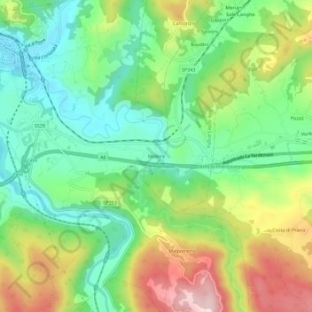
Name: Mollere topographic map, elevation, terrain.

Location: Mollere, Ceva, Cuneo, Piedmont, 12073, Italy (44.35348 8.04232 44.39348 8.08232)

Average elevation: 1,670 ft

Minimum elevation: 1,237 ft

Maximum elevation: 2,385 ft

Gear up for your next adventure:

🩹Survival Bandages - High‑quality bandages for emergencies
🚪Portable Camp Chair - Foldable chair for comfort at camp
🪵Folding Camp Saw - Compact saw for wood and campsite work
🥤Water Filter Bottle - All‑in‑one filter bottle for safe hydration
🔋Rechargeable Batteries - Power up your outdoor devices

As an Amazon Associate, this site earns from qualifying purchases at no extra cost to you.