
Make a donation
Gear up for your next adventure:
As an Amazon Associate, this site earns from qualifying purchases at no extra cost to you.
Tegelen topographic map
Click on the map to display elevation.
Make a donation
Gear up for your next adventure:
As an Amazon Associate, this site earns from qualifying purchases at no extra cost to you.
Tegelen
Tegelen ligt aan de Maas op een hoogte van ongeveer 18 meter. Naar het oosten toe, op het hoogterras, loopt de hoogte op tot bijna 50 meter. Hier bevinden zich de kleigroeven, en er ligt het natuurgebied Holtmühle, dat in Duitsland aansluit op het natuurgebied Ravensheide en het Brachterwald. Meer naar het noorden vindt men de Onderste en Bovenste Molen en het natuurgebied Jammerdaalse Heide.
Make a donation
Gear up for your next adventure:
As an Amazon Associate, this site earns from qualifying purchases at no extra cost to you.
About this map
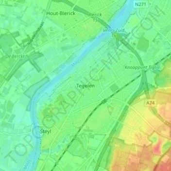
Name: Tegelen topographic map, elevation, terrain.
Location: Tegelen, Venlo, Limburg, Nederland, 5931EP, Nederland (51.32293 6.11622 51.36293 6.15622)
Average elevation: 79 ft
Minimum elevation: 30 ft
Maximum elevation: 171 ft
Make a donation
Gear up for your next adventure:
As an Amazon Associate, this site earns from qualifying purchases at no extra cost to you.