
Make a donation
Gear up for your next adventure:
As an Amazon Associate, this site earns from qualifying purchases at no extra cost to you.
Zarautz topographic map
Click on the map to display elevation.
Make a donation
Gear up for your next adventure:
As an Amazon Associate, this site earns from qualifying purchases at no extra cost to you.
About this map
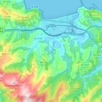
Name: Zarautz topographic map, elevation, terrain.
Average elevation: 417 ft
Minimum elevation: 0 ft
Maximum elevation: 1,493 ft
Make a donation
Gear up for your next adventure:
As an Amazon Associate, this site earns from qualifying purchases at no extra cost to you.
Other topographic maps
Click on a map to view its topography, its elevation and its terrain.
Makola
Spain > Autonomous Community of the Basque Country > Urola-Kosta > Azkoitia
Average elevation: 1,690 ft
Flysch
Spain > Autonomous Community of the Basque Country > Urola-Kosta > Zumaia
Average elevation: 89 ft
Floreaga
Spain > Autonomous Community of the Basque Country > Urola-Kosta > Azkoitia
Average elevation: 873 ft