
Thank you for supporting this site ❤️
Make a donation
Make a donation
Gear up for your next adventure:
As an Amazon Associate, this site earns from qualifying purchases at no extra cost to you.
Miñarica topographic map
Click on the map to display elevation.
Thank you for supporting this site ❤️
Make a donation
Make a donation
Gear up for your next adventure:
As an Amazon Associate, this site earns from qualifying purchases at no extra cost to you.
About this map
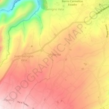
Name: Miñarica topographic map, elevation, terrain.
Location: Miñarica, Santa Rosa, Ambato, Tungurahua, 180213, Ecuador (-1.32000 -78.70333 -1.28000 -78.66333)
Average elevation: 10,148 ft
Minimum elevation: 9,026 ft
Maximum elevation: 10,797 ft
Thank you for supporting this site ❤️
Make a donation
Make a donation
Gear up for your next adventure:
As an Amazon Associate, this site earns from qualifying purchases at no extra cost to you.