
Thank you for supporting this site ❤️
Make a donation
Make a donation
Gear up for your next adventure:
As an Amazon Associate, this site earns from qualifying purchases at no extra cost to you.
Corinto topographic map
Click on the map to display elevation.
Thank you for supporting this site ❤️
Make a donation
Make a donation
Gear up for your next adventure:
As an Amazon Associate, this site earns from qualifying purchases at no extra cost to you.
About this map
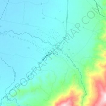
Name: Corinto topographic map, elevation, terrain.
Location: Corinto, Norte, Cauca, RAP Pacífico, Colombia (3.13337 -76.30003 3.21337 -76.22003)
Average elevation: 3,766 ft
Minimum elevation: 3,281 ft
Maximum elevation: 6,237 ft
Thank you for supporting this site ❤️
Make a donation
Make a donation
Gear up for your next adventure:
As an Amazon Associate, this site earns from qualifying purchases at no extra cost to you.