
Thank you for supporting this site ❤️
Make a donation
Make a donation
Gear up for your next adventure:
As an Amazon Associate, this site earns from qualifying purchases at no extra cost to you.
Kuressaare topographic map
Click on the map to display elevation.
Thank you for supporting this site ❤️
Make a donation
Make a donation
Gear up for your next adventure:
As an Amazon Associate, this site earns from qualifying purchases at no extra cost to you.
About this map
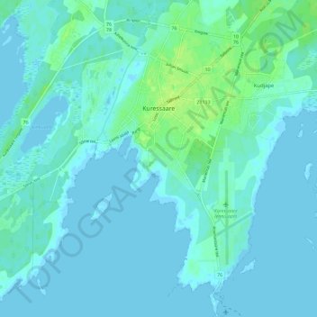
Name: Kuressaare topographic map, elevation, terrain.
Location: Kuressaare, Saaremaa vald, Saare County, Estonia (58.21283 22.44049 58.27325 22.52737)
Average elevation: 10 ft
Minimum elevation: -3 ft
Maximum elevation: 36 ft
Thank you for supporting this site ❤️
Make a donation
Make a donation
Gear up for your next adventure:
As an Amazon Associate, this site earns from qualifying purchases at no extra cost to you.