
Make a donation
Gear up for your next adventure:
As an Amazon Associate, this site earns from qualifying purchases at no extra cost to you.
Torgau topographic map
Click on the map to display elevation.
Make a donation
Gear up for your next adventure:
As an Amazon Associate, this site earns from qualifying purchases at no extra cost to you.
Torgau
Die Stadt Torgau liegt im Norden des Freistaates Sachsen am westlichen Ufer der Elbe in einer Höhe von etwa 85 Metern über dem Meeresspiegel. Westlich von Torgau beginnt die Dübener Heide, die sich im Westen bis Eilenburg und im Norden bis Gräfenhainichen und Kemberg erstreckt. Südwestlich der Stadt liegt der Große Teich, der vom Schwarzen Graben, aus Richtung Audenhain kommend, gespeist wird. An den See schließt sich südlich der Torgauer Ratsforst an.
Make a donation
Gear up for your next adventure:
As an Amazon Associate, this site earns from qualifying purchases at no extra cost to you.
About this map
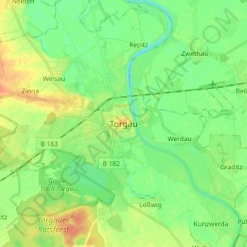
Name: Torgau topographic map, elevation, terrain.
Location: Torgau, Nordsachsen, Sachsen, 04860, Deutschland (51.51813 12.96465 51.59813 13.04465)
Average elevation: 282 ft
Minimum elevation: 233 ft
Maximum elevation: 351 ft
Make a donation
Gear up for your next adventure:
As an Amazon Associate, this site earns from qualifying purchases at no extra cost to you.