
Thank you for supporting this site ❤️
Make a donation
Make a donation
Gear up for your next adventure:
As an Amazon Associate, this site earns from qualifying purchases at no extra cost to you.
Komperdell topographic map
Click on the map to display elevation.
Thank you for supporting this site ❤️
Make a donation
Make a donation
Gear up for your next adventure:
As an Amazon Associate, this site earns from qualifying purchases at no extra cost to you.
About this map
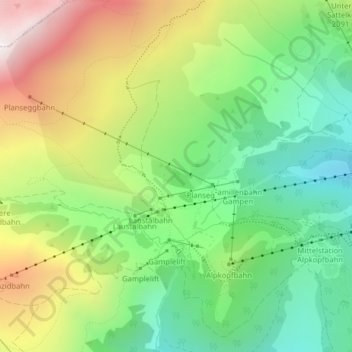
Name: Komperdell topographic map, elevation, terrain.
Location: Komperdell, Serfaus, Bezirk Landeck, Tyrol, 6534, Austria (47.03248 10.55444 47.05248 10.57444)
Average elevation: 6,601 ft
Minimum elevation: 5,203 ft
Maximum elevation: 8,711 ft
Thank you for supporting this site ❤️
Make a donation
Make a donation
Gear up for your next adventure:
As an Amazon Associate, this site earns from qualifying purchases at no extra cost to you.
Other topographic maps
Click on a map to view its topography, its elevation and its terrain.