
Delta topographic map
Click on the map to display elevation.
About this map
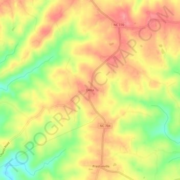
Name: Delta topographic map, elevation, terrain.
Location: Delta, Stokes County, North Carolina, 27046, United States (36.45458 -80.12116 36.49458 -80.08116)
Average elevation: 1,033 ft
Minimum elevation: 853 ft
Maximum elevation: 1,158 ft
Stokes County trails, hiking, mountain biking, running and outdoor activities
Other topographic maps
Click on a map to view its topography, its elevation and its terrain.
Hanging Rock State Park
United States > North Carolina > Stokes County > Danbury
Hanging Rock State Park is located in the Sauratown Mountain Range, one of the most easterly mountain ranges in the state. Often called "the mountains away from the mountains," the Sauratown range is made up of monadnocks that are separated from the nearby Blue Ridge Mountains. The Sauratown Mountains lie…
Average elevation: 1,060 ft