
Thank you for supporting this site ❤️
Make a donation
Make a donation
Gear up for your next adventure:
As an Amazon Associate, this site earns from qualifying purchases at no extra cost to you.
Estahban topographic map
Click on the map to display elevation.
Thank you for supporting this site ❤️
Make a donation
Make a donation
Gear up for your next adventure:
As an Amazon Associate, this site earns from qualifying purchases at no extra cost to you.
Estahban
Estahban is located at 29.1291° N, 54.358° E and surrounded by Bakhtagan Lake from the north, by Fars township from the south and by Shiraz and Darab from the west. Its average elevation from sea level is about 1767 m.
Thank you for supporting this site ❤️
Make a donation
Make a donation
Gear up for your next adventure:
As an Amazon Associate, this site earns from qualifying purchases at no extra cost to you.
About this map
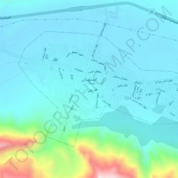
Name: Estahban topographic map, elevation, terrain.
Average elevation: 5,965 ft
Minimum elevation: 5,633 ft
Maximum elevation: 7,690 ft
Thank you for supporting this site ❤️
Make a donation
Make a donation
Gear up for your next adventure:
As an Amazon Associate, this site earns from qualifying purchases at no extra cost to you.