
Fort Dick topographic map
Click on the map to display elevation.
About this map
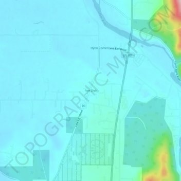
Name: Fort Dick topographic map, elevation, terrain.
Average elevation: 79 ft
Minimum elevation: -3 ft
Maximum elevation: 755 ft
Del Norte County trails, hiking, mountain biking, running and outdoor activities
Other topographic maps
Click on a map to view its topography, its elevation and its terrain.
Redwood National Park
United States > California > Del Norte County
Redwoods prefer sheltered slopes, and they thrive on moist flat ground along rivers below 1,000 feet (300 m) in elevation. Coastal fog provides about 40 percent of their annual water intake. Redwoods have existed along the coast of northern California for at least 20 million years and are related to tree…
Average elevation: 1,204 ft
Klamath
United States > California > Del Norte County > Klamath
Klamath (Tolowa: Taa-chit) is an unincorporated community in Del Norte County, California, United States, situated on US Route 101, inland from the mouth of the Klamath River. The population of Klamath is 1088 based on the 2020 US Census. For statistical purposes, the United States Census Bureau has defined…
Average elevation: 407 ft
Crescent City
United States > California > Del Norte County
The topography of the sea floor surrounding Crescent City has the effect of focusing tsunamis. According to researchers at Humboldt State University and the University of Southern California, the city experienced tsunami conditions 31 times between the years 1933 and 2008. Although many of these incidents were…
Average elevation: 102 ft
Klamath
United States > California > Del Norte County > Klamath
Klamath (Tolowa: Taa-chit) is an unincorporated community in Del Norte County, California, United States, situated on US Route 101, inland from the mouth of the Klamath River. The population of Klamath is 1088 based on the 2020 US Census. For statistical purposes, the United States Census Bureau has defined…
Average elevation: 407 ft
Redwood National and State Parks
United States > California > Del Norte County
Redwoods prefer sheltered slopes, and they thrive on moist flat ground along rivers below 1,000 feet (300 m) in elevation. Coastal fog provides about 40 percent of their annual water intake. Redwoods have existed along the coast of northern California for at least 20 million years and are related to tree…
Average elevation: 1,063 ft
Crescent City
United States > California > Del Norte County
The topography of the sea floor surrounding Crescent City has the effect of focusing tsunamis. According to researchers at Humboldt State University and the University of Southern California, the city experienced tsunami conditions 31 times between the years 1933 and 2008.[25] Although many of these incidents…
Average elevation: 20 ft