
Thank you for supporting this site ❤️
Make a donation
Make a donation
Gear up for your next adventure:
As an Amazon Associate, this site earns from qualifying purchases at no extra cost to you.
Fornaka topographic map
Click on the map to display elevation.
Thank you for supporting this site ❤️
Make a donation
Make a donation
Gear up for your next adventure:
As an Amazon Associate, this site earns from qualifying purchases at no extra cost to you.
About this map
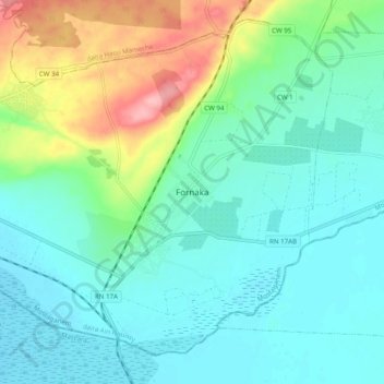
Name: Fornaka topographic map, elevation, terrain.
Location: Fornaka, Aïn Nouissy District, Mostaganem, Algeria (35.71197 -0.05670 35.79197 0.02330)
Average elevation: 118 ft
Minimum elevation: 10 ft
Maximum elevation: 440 ft
Thank you for supporting this site ❤️
Make a donation
Make a donation
Gear up for your next adventure:
As an Amazon Associate, this site earns from qualifying purchases at no extra cost to you.