
Make a donation
Gear up for your next adventure:
As an Amazon Associate, this site earns from qualifying purchases at no extra cost to you.
Dikkele topographic map
Click on the map to display elevation.
Make a donation
Gear up for your next adventure:
As an Amazon Associate, this site earns from qualifying purchases at no extra cost to you.
Dikkele
De dorpskern van Dikkele is niet enkel door monumentenzorg beschermd. Ook geografisch is er sprake van een beschermende omgeving, door de ligging in een kom waardoor op enige afstand van het dorp nauwelijks meer te zien is dan de punt van de kerktoren. Hoewel deze kom zelf op een hoogte ligt, is de bodem er zeer drassig vanwege een ondiepe kleilaag die waterinsijpeling bemoeilijkt.
Make a donation
Gear up for your next adventure:
As an Amazon Associate, this site earns from qualifying purchases at no extra cost to you.
About this map
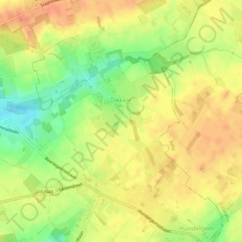
Name: Dikkele topographic map, elevation, terrain.
Location: Dikkele, Zwalm, Oudenaarde, Oost-Vlaanderen, Vlaanderen, België (50.89409 3.72912 50.90826 3.75229)
Average elevation: 157 ft
Minimum elevation: 75 ft
Maximum elevation: 207 ft
Make a donation
Gear up for your next adventure:
As an Amazon Associate, this site earns from qualifying purchases at no extra cost to you.
Other topographic maps
Click on a map to view its topography, its elevation and its terrain.
Make a donation
Gear up for your next adventure:
As an Amazon Associate, this site earns from qualifying purchases at no extra cost to you.