
Make a donation
Gear up for your next adventure:
As an Amazon Associate, this site earns from qualifying purchases at no extra cost to you.
Kill Devil Hills topographic map
Click on the map to display elevation.
Make a donation
Gear up for your next adventure:
As an Amazon Associate, this site earns from qualifying purchases at no extra cost to you.
Kill Devil Hills
First Flight Airport covers an area of 40 acres at an elevation of 13 feet (4 metres) above mean sea level. It has one runway; designated 2/20, with an asphalt surface measuring 3,000 by 60 feet (914 by 18 metres). For the 12-month period ending August 19, 2009, the airport had 38,120 aircraft operations, an average of 104 per day: 97% general aviation, 3% air taxi, and <1% military.
Make a donation
Gear up for your next adventure:
As an Amazon Associate, this site earns from qualifying purchases at no extra cost to you.
About this map
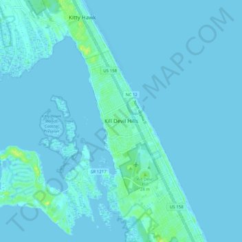
Name: Kill Devil Hills topographic map, elevation, terrain.
Average elevation: 3 ft
Minimum elevation: -13 ft
Maximum elevation: 49 ft
Dare County trails, hiking, mountain biking, running and outdoor activities
Make a donation
Gear up for your next adventure:
As an Amazon Associate, this site earns from qualifying purchases at no extra cost to you.