
Make a donation
Gear up for your next adventure:
As an Amazon Associate, this site earns from qualifying purchases at no extra cost to you.
Kwaremont topographic map
Click on the map to display elevation.
Make a donation
Gear up for your next adventure:
As an Amazon Associate, this site earns from qualifying purchases at no extra cost to you.
Kwaremont
Kwaremont ligt in de Vlaamse Ardennen, de hoogte varieert van 15 meter in de Scheldevallei tot 125 meter op een uitloper van de Kluisberg. Verder zijn er de Paterberg en de Kwaremontberg. Op de hellingen van de heuvels ontspringen beekjes die uiteindelijk naar de Schelde vloeien. Op de hellingen zijn bossen aanwezig en in de nabijheid van de Schelde zijn vochtige meersen.
Make a donation
Gear up for your next adventure:
As an Amazon Associate, this site earns from qualifying purchases at no extra cost to you.
About this map
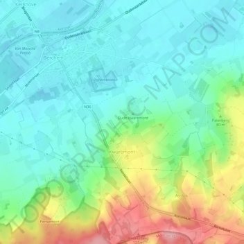
Name: Kwaremont topographic map, elevation, terrain.
Location: Kwaremont, Oudenaarde, Oost-Vlaanderen, Vlaanderen, België (50.76290 3.51292 50.79885 3.56534)
Average elevation: 144 ft
Minimum elevation: 20 ft
Maximum elevation: 440 ft
Make a donation
Gear up for your next adventure:
As an Amazon Associate, this site earns from qualifying purchases at no extra cost to you.
Other topographic maps
Click on a map to view its topography, its elevation and its terrain.
Make a donation
Gear up for your next adventure:
As an Amazon Associate, this site earns from qualifying purchases at no extra cost to you.