
Make a donation
Gear up for your next adventure:
As an Amazon Associate, this site earns from qualifying purchases at no extra cost to you.
Evanston topographic map
Click on the map to display elevation.
Make a donation
Gear up for your next adventure:
As an Amazon Associate, this site earns from qualifying purchases at no extra cost to you.
Evanston
Evanston is located at 41°15′48″N 110°57′53″W / 41.26333°N 110.96472°W / 41.26333; -110.96472 (41.263302, −110.964616). The elevation is 6749 feet (2057 m) above sea level.
Make a donation
Gear up for your next adventure:
As an Amazon Associate, this site earns from qualifying purchases at no extra cost to you.
About this map
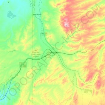
Name: Evanston topographic map, elevation, terrain.
Location: Evanston, Uinta County, Wyoming, 82931, United States (41.10825 -111.12376 41.42825 -110.80376)
Average elevation: 7,077 ft
Minimum elevation: 6,286 ft
Maximum elevation: 8,589 ft
Uinta County trails, hiking, mountain biking, running and outdoor activities
Make a donation
Gear up for your next adventure:
As an Amazon Associate, this site earns from qualifying purchases at no extra cost to you.